Lucas County
|
Learn More |
There are many reasons why access management is vital. It extends the life of roads and streets and protects the public’s investment in its system. When development occurs along a road and driveways begin to proliferate, capacity and safety decrease drastically. The crash rate of roads with numerous uncontrolled driveways is 4 to 6 times the rate of similar roads where access is managed. And managing access on a four-lane road is equivalent to adding two more lanes of capacity, and at a cost far less than that required to add lanes. Even if one weren’t concerned about maintaining existing roads and streets, the likelihood of obtaining large sums of money to widen and/or replace existing roads is decreasing as transportation infrastructure needs and costs continue to outpace available funding.
Numerous un-controlled driveway accesses along a roadway create delay as drivers maneuver to avoid the conflict points and a considerable number of crashes when drivers fail to avoid them. It results in turbulence and friction which in turn raise driver tension, and when driver tension is increased, the potential for tip-over into road rage is increased as well.
|
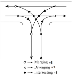
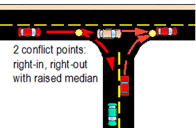
Conflict points are reduced at 4-way and tee intersections when these access points become right-in/right-out. The reductions are dramatic and result in significantly improved traffic flow resulting in reduced congestion and crashes. And, in a more general way, they illustrate why the development of standards and policies establishing access management are very important if the integrity and safety of our road system are to be maintained.
|
The Lucas County Engineer’s Office worked with an Access Management Advisory Group to create standards, policies and procedures for access management regulations. The regulations cover the County road system and township roads.
The process began in March 2006, when the County Commissioners adopted a resolution proposing the consideration of access management regulations. This was followed by solicitation of members to serve on the Advisory Committee and organizational meeting in June 2006.
The committee, which had 20 members, represents the many areas and fields of endeavor with an interest in access management, and the many different viewpoints assure that proposals are evaluated and discussed.
The regulations were developed for each of six categories of roads on the existing Lucas County Thoroughfare System. These categories include the following (with examples):
· Major Arterials
· Minor Arterials McCord Road , Albon Road, Centennial Road
· Major Collectors King Road , North Curtice Road , Neowash Road
· Minor Collectors Frankfort Road, Heller Road, Seaman Road
· Minor Collectors (2nd Class) Lyon Road, Keener Road, Coder Road, Kilburn Road
· Locals Roads primarily serving abutting properties
Also determined were access connection definitions (roads & streets, drives, etc.); access classification definitions, ranging from minimum-volume drives up to high-volume drives and streets; minimum signal spacing; minimum road or street spacing; minimum full-access driveway spacing; right-in/right-out requirements; corner spacing; left-turn lane and right-turn lane requirements; and lateral access restrictions. All of the requirements are shown on matrices, one for each functional classification.


